RADE: A Risk Analytics Discovery Environment

Coastal property values are sensitive to many factors, including environmental stressors related to changing regional climate and changing sea levels. Predictions of property value changes are essential for coastal planning and development, and form a central part of understanding our state’s exposure to long‐term coastal hazards, particularly the co‐occurrence of tropical cyclones and rising sea levels. Essentially, can we predict long‐term changes in coastal property values and quantify associated uncertainty? What are the impacts of various levels of sea level increase on present and future coastal property values?

This use case will develop a predictor of coastal property values in RADE, and then use that predictor to examine changes under future scenarios of climate and sea level changes. Given other geospatial data to describe a coastal property, the predictor will estimate the assessed price per square foot. Once a reliable predictor model is established, we will perturb it with scenarios of storm winds and flooding from detailed storm surge and wave simulations from the ADCIRC model (Westerink et al, 2008). RENCI has a very large database of ADCIRC simulations from recent FEMA‐funded coastal risk assessments, including the Coastal Flood Insurance Study (Blanton and Luettich, 2010) and a comprehensive Sea Level Rise Impacts Assessment (NCDEM, 2009). We will insert the relevant outputs of these NC coastal model results into the data grid for use by this use case and any other interested researchers. The output includes inundation extents from a sequence of sea level rise increments up to 1 meter, various derived quantities for wind wave impacts, and coastal flooding.

WC Lenhardt, et al. “RADE: A Risk Analytics Discovery Environment.” UNC Research Opportunities Initiative, North Carolina Data Science and Analytics Initiative, 2015/07/01 to 2017/06/30, (Dietrich: $27,270).

News: Developing Storm Surge Visualization

2015/03/10 – CCEE
Developing Storm Surge Visualization

ncsu-engr

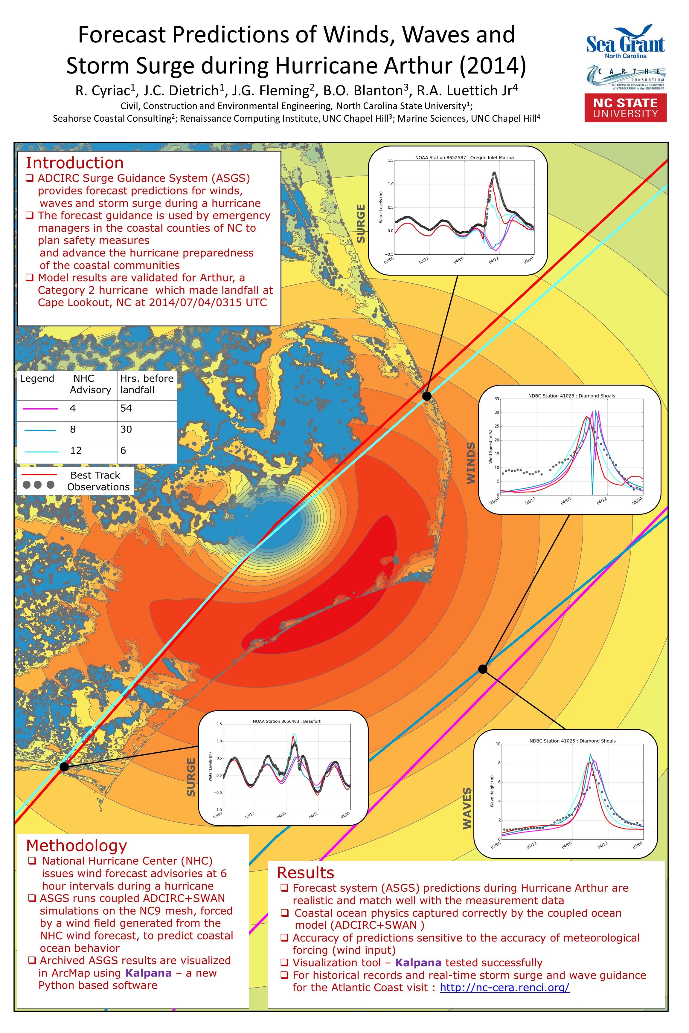
When tropical storms approach, local, state and federal emergency managers seek predictions of storm surge and coastal flooding. In a project supported by NC Sea Grant, Dr. Casey Dietrich and Ph.D. student Rosemary Cyriac are improving the dissemination of flooding predictions to end-users by producing predictions in popular file formats. The Coastal Emergency Risk Assessment (CERA, http://nc-cera.renci.org/) provides a Web-based interface for visualizing surge predictions from computer models. Dr. Dietrich’s team is working with emergency managers in North Carolina’s coastal counties and with other decision makers. Results from daily model simulations are sent to these individuals, and they are widely used to predict inundation and flooding levels. Such predictions are also needed for engineering design and evacuation decisions. Model outputs are converted into formats compatible with commonly used visualization software, such as ArcGIS and Google Earth. By providing predictions to local emergency managers in a useful format, the information can be more easily integrated with other data, thereby making the information more accessible to those who most need it.

Poster: NCSU Symposiums 2015

R Cyriac, JC Dietrich, JG Fleming, BO Blanton, RA Luettich, C Kaiser. “Forecast Predictions of Winds, Waves and Storm Surge during Hurricane Arthur (2014).” Graduate Student Research Symposium, North Carolina State University, 25 March 2015.

R Cyriac, JC Dietrich, JG Fleming, BO Blanton, RA Luettich, C Kaiser. “Forecast Predictions of Winds, Waves and Storm Surge during Hurricane Arthur (2014).Environmental, Water Resources and Coastal Engineering Research Symposium, North Carolina State University, 06 March 2015.

Rosemary_Poster_WREESymposium_2015