Category Archives: Models
Conference: ECM 2016
News: Sea Grant Research Tackles Important Issues
 2016/05/18 – NC Sea Grant Coastwatch Currents
Considering Coastal Questions: Sea Grant Research Tackles Important Issues
Beach erosion during storm events can devastate the natural environment and coastal communities. This research team seeks to improve simulations of coastal flooding in regions where the beach erosion is highly dynamic. Such simulations are used in North Carolina and elsewhere for designing buildings, establishing flood insurance rates, and supporting real-time decisions during storm events.
The research will review effects of hurricanes Isabel and Irene on oceanfront and soundside shorelines for Hatteras Island, as well as how storm-induced flooding pushed inland. New predictions will be strengthened as the data are coupled with a beach-erosion model. The team will share results with local- and state-level partners to show connections not only throughout the island system but also related impacts on mainland communities.
Presentation: CARTHE 2016
Conference: ADCIRC 2016
Seminar: Jackson State University
News: National Consortium for Data Science chooses Data Fellows
 2016/04/28 – NCDS
National Consortium for Data Science chooses researchers from three universities as 2016 -2017 Data Fellows
Three researchers located at Drexel University, North Carolina State University, and the University of North Carolina at Chapel Hill have been named 2016 -2017 Data Fellows by the National Consortium for Data Science (NCDS) the consortium announced today.
Researchers in North Carolina use the Advanced CIRCulation (ADCIRC) model to provide real-time information about storm surge, water inundation, wind speeds, and wave heights during coastal storms. These models are produced constantly during major storms, however, communicating the information in the simulations to end users, such as emergency managers, is more challenging. This project will use visualization techniques to bring ADCIRC model data to emergency managers so they can quickly identify, analyze, and disseminate information about high-risk areas. By incorporating the model data with other data sources, the researchers hope to enable informed decision-making about evacuations and other disaster management efforts.
Poster: NCSU Symposiums 2016
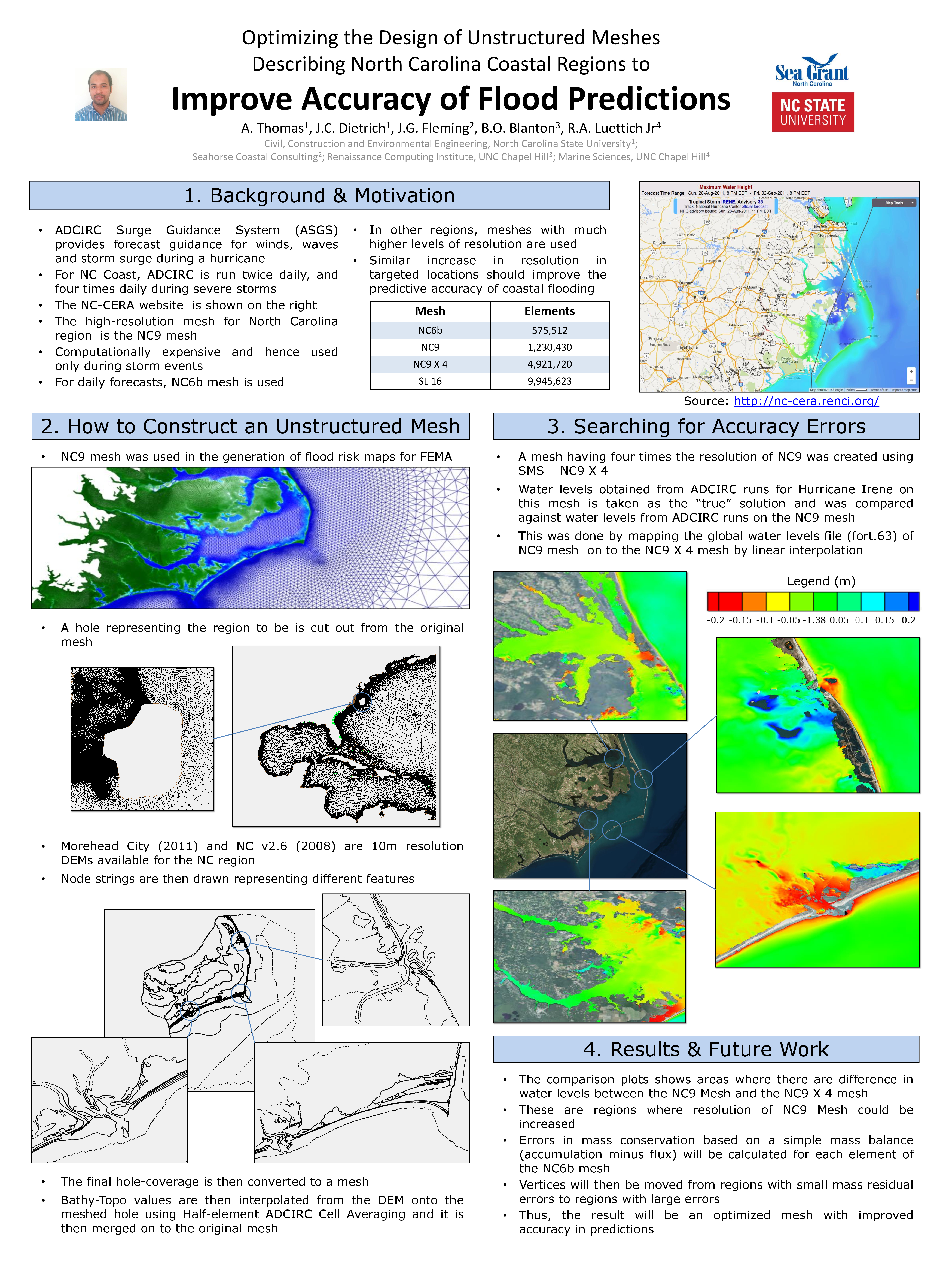
A Thomas, JC Dietrich, JG Fleming, BO Blanton, RA Luettich Jr. “Optimizing the Design of Unstructured Meshes Describing North Carolina Coastal Regions to Improve Accuracy of Flood Predictions.” Environmental, Water Resources and Coastal Engineering Research Symposium, North Carolina State University, 04 March 2016.
A Thomas, JC Dietrich, JG Fleming, BO Blanton, RA Luettich Jr. “Optimizing the Design of Unstructured Meshes Describing North Carolina Coastal Regions to Improve Accuracy of Flood Predictions.” Computing & Systems Research Symposium, North Carolina State University, 22 April 2016.